"Minnesota Mound Site Map"

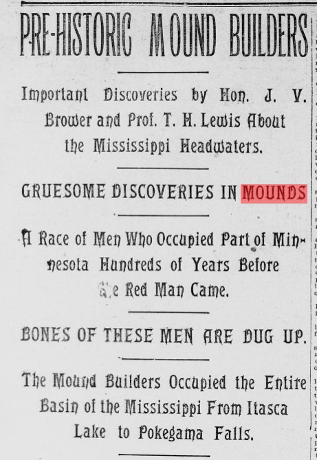
The Minnesota Mound Builders of the Mississippi Headwaters
In the summer of 1895, Minnesota archaeologist J. V. Brower and surveyor T. H. Lewis set out to document an ancient landscape that most settlers only glimpsed from canoes and logging roads: the mounds and village sites of a forgotten people around the headwaters of the Mississippi River. Their work, published in the St. Paul Daily Globe that August, traced burial mounds, effigy earthworks, and old village sites from Park Rapids and Lake Itasca northward through Bemidji, Cass Lake, Leech Lake, and the portages that knit these waters together. What emerged was a picture of a mound‑building population that had occupied the upper Mississippi basin long before the historic Ojibwe and Sioux, leaving behind a chain of earthworks and artifacts that still shapes how archaeologists understand northern Minnesota.Minnesota-Mound-Map.pdf
Who were these Mound Builders?
Brower described them as a distinct “mound‑building race” that predated the tribes then living in the region but whose earthworks those tribes later reused for their own burials and camps. From the skeletal remains he exhumed, he estimated their average height at roughly five and a half to just over six feet, and he considered their skulls regular and symmetrical enough to suggest intelligence and planning rather than a crude or primitive existence. In his view, these people were organized builders who created effigy mounds, village sites, and portage systems, and they were more culturally advanced than the Ojibwe who occupied the same lands in the 19th century.Minnesota-Mound-Map.pdf
What Brower and Lewis actually found
The Globe article summarizes months of work in the field, beginning with the Dickenson mounds near Park Rapids, where Brower counted at least twenty‑two mounds and embankments within one group. Many of these were circular or elliptical burial mounds built of sandy loam and raised only a few feet above the surrounding ground, yet they contained original interments buried near the base of the mound above the old land surface. Deeper excavations at the so‑called Lewis mounds, south of the Mississippi headwaters, exposed calcined human bones resting directly on natural gravel, with at least five recognizable skulls and the fragments of several more mixed into a heap of charred remains.Minnesota-Mound-Map.pdf
In some mounds, Brower noted several distinct burial episodes. At one site, a lower mass of calcined bone lay at the bottom, then above it a layer of more decomposed skulls and bones, and above those yet another intrusive burial wrapped in birch bark that he attributed to later Sioux or Ojibwe use of the same mound. Elsewhere, he encountered small ash beds, charcoal pockets, and scattered animal bones and pottery fragments, which suggested both domestic activity and ritual treatment of the dead but did not always show clear evidence of fires being lit inside the mound itself. The overall impression was of a people who often removed flesh from the bones and sometimes burned them before burial, apparently aiming at long‑term preservation rather than destruction.Minnesota-Mound-Map.pdf
Where the mound sites and villages were located
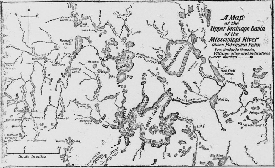
Using survey instruments, government plats, and painstaking boat travel, Brower and Lewis plotted a continuous belt of prehistoric occupation along the upper Mississippi and its tributaries. Near Park Rapids, they found the Dickenson mounds and additional earthworks at Fishhook Lake, with stone spearpoints and arrowheads proving a prehistoric origin for the complex. Around Lake Itasca and Point Hill, they recorded both mounds and bone heaps containing the remains of moose, bear, deer, wolf, beaver, and fox, mixed with pottery shards, spalls, burned hearthstones, and triangular arrow points—clear signs of a settled village rather than a single hunting camp.Minnesota-Mound-Map.pdf
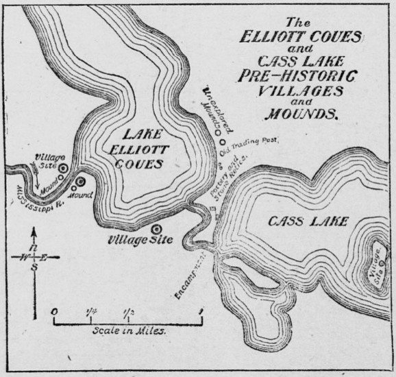
Farther downriver, they identified village sites and mound clusters at Bemidji Lake and Lake Irving, along the Naiwa River, and at Cass Lake and Pike Bay, where plowed fields and eroding sand banks constantly turned up pottery and chipped stone tools. One of the most striking areas lay near Tascodiac Lake, where Brower discovered four large sand effigy mounds on the high hills north of the Mississippi, containing more than a hundred tons of earth and overlooking extensive village sites along the lake and river. When he excavated the most southerly of these effigies, he found a circular burial mound about forty feet in diameter and three and a half feet high that contained at least thirty‑five skulls within a shaft scarcely five feet across, along with numerous other bones and deliberately placed boulders above some of the heads. North of Leech Lake, he mapped what he believed to be a great central village, stretching for miles along a broad point of land whose mounds and artifact scatters were dense enough that he christened it “Mound Point.”Minnesota-Mound-Map.pdf
When these sites were occupied
The Globe article does not attach precise calendar dates to the mounds, but Brower makes it clear that he regards them as ancient. He suggests that the region could have been occupied by mound‑builders more than twelve hundred years earlier, possibly by a smaller population living in the area for a long time rather than a large group over a short period. In support of this, he points to the great age suggested by some of the remains, the depth and weathering of the mounds, and the intrusive burials of later Ojibwe near the surface, which show that even by the time historic tribes arrived, the original earthworks were already old.Minnesota-Mound-Map.pdf
Brower also argues that the major portages between Itasca, Cass, Leech, Red Lake, and the Crow Wing system—the same trails used by Morrison, Pike, Schoolcraft, and their Ojibwe guides—must have originated with the earlier mound‑building population. In his reconstruction, these prehistoric travelers first opened the Cut Foot Sioux, Shingobi, and other portages, then established their villages at lake outlets and along easy carries, and only later did the Sioux, Ojibwe, and fur‑trade explorers step into this pre‑existing network.Minnesota-Mound-Map.pdf
Why the mounds were built
From Brower’s perspective, the mounds served several intertwined purposes. Many were clearly burial mounds, sometimes containing dozens of individuals, with bones arranged in ways that suggest complex mortuary customs rather than hasty interment. He notes that in at least one Tascodiac mound, the bones appeared to have been cleaned of flesh and in some cases calcined, as if the builders wanted to preserve the skeletons by sealing them in a dry, sandy tomb. Other mounds, especially the effigies, may have functioned as ceremonial or religious structures, built of pure sand and commanding prominent views yet not always yielding obvious burials when probed.Minnesota-Mound-Map.pdf
At the same time, the distribution of mounds and associated artifact scatters shows that the builders lived in villages along lake shores and riverbanks, close to fish runs, game, and travel routes. Brower concludes that they subsisted largely on hunting and fishing, used pottery vessels made from clay tempered with stone, sand, or crushed shell, and relied on stone and copper tools, bows and arrows, and some combination of skin, bark, or log canoes. He finds no clear evidence of cannibalism; instead, the careful handling of bones and the construction of large communal mounds suggest respect for the dead and a desire to create long‑lasting monuments in the landscape.Minnesota-Mound-Map.pdf
Images and maps of the Minnesota mound sites
The 1895 Globe feature that underlies your PDF included engraved maps and diagrams showing the locations and outlines of the mound groups Brower surveyed, including the Dickenson mounds near Park Rapids, the Lewis mounds near the Mississippi headwaters, and the effigy mounds near Tascodiac. Those maps plot diameters, heights, and approximate shapes of individual mounds and mark nearby village sites, lakes, and portages, giving a visual sense of how thoroughly the mound‑builders occupied the headwaters region. Later state reports and Brower’s own monographs reused and refined these illustrations, adding more precise surveys and cross‑sections but still echoing the same pattern: a chain of mounds and villages hugging the waterways of northern Minnesota, silent but enduring evidence of a sophisticated Indigenous landscape that long predates written history.Minnesota-Mound-Map.pdf
- https://ghost.org/resources/how-to-format-a-blog-post/
- https://www.youtube.com/watch?v=50s7U_VSG3c
- https://bloggingwizard.com/how-to-format-blog-posts/
- https://surferseo.com/blog/perfect-blog-post-structure/
- https://bdow.com/stories/blog-post-format/
- https://saradoesseo.com/website-tips/format-blog-post/
- https://parallelpath.com/blog/blog-formatting-and-style-best-practices/
- https://joshsteimle.com/writing/formatting-tips-for-your-first-blog-post.html
- https://www.naeyc.org/our-work/public-policy-advocacy/guidelines-writing-effective-blog-post
- https://www.blogmarketingacademy.com/perfect-blog-post-2-2/
- https://ppl-ai-file-upload.s3.amazonaws.com/web/direct-files/attachments/28700284/c9e3bded-6d46-4658-a1d8-dc1f5c66db16/Minnesota-Mound-Map.pdf
Gallery
Discussion (0)
Please sign in to join the discussion
No comments yet. Be the first to share your thoughts!