“Mapping Alabama’s Ancient Mound Sites from ‘Pioneer Days’.”

Ancient mound sites described by Mary Gordon Duffee in “Pioneer Days” are concentrated in Alabama, and many can still be roughly located today using modern place names, rivers, and towns.
Mapping Alabama’s Ancient Mound Sites from “Pioneer Days”
Ancient earthworks, stone heaps, and burial mounds are scattered across Alabama’s valleys and river bottoms, often reused by later Native peoples as convenient cemeteries. The original builders remain unknown, but the works described in Mary Gordon Duffee’s “Pioneer Days” can be tied to specific modern locations, making them easier to find and research today.pioneer.pdf
Calhoun & Talladega Region (East-Central Alabama)
- Large isolated mound near Oxford (Calhoun County, AL)
- About three miles southeast of Oxford, on the Caver Plain near Choccolocco Creek, stands (or once stood) a large isolated mound. This area corresponds today to the Choccolocco Creek Archaeological Complex around Oxford, Calhoun County, Alabama.alabamamoundtrail+1
- pioneer.pdf
-
- Orderly group of mounds on Choccolocco Creek (Calhoun/Talladega County line, AL)
- A group of “orderly arranged” mounds was reported about 15 miles southwest of Oxford, on the south bank of Choccolocco Creek, likely in southern Calhoun or northern Talladega County, Alabama. These lie in the broader Choccolocco Creek watershed, a major tributary of the Coosa River.wikipedia+1
- pioneer.pdf
-
- Old Creek Indian settlement at Cragsdale (Talladega County, AL)
- On Talladega Creek, about four miles southeast of the city of Talladega, an old Creek settlement once occupied the site known as Cragsdale, with bones, shells, pottery, and shell ornaments recorded there. Talladega Creek flows through Talladega County in east-central Alabama, a short distance southeast of modern Talladega.pioneer.pdf
-
- Ancient mica quarry and workshops (Talladega County, AL)
- Duffee notes an ancient mica quarry in section 12, township 20 south, range 6 east, and Indian workshops on the headwaters of Talladega Creek at the eastern end of Cedar Ridge, all in Talladega County, Alabama. These are upland industrial sites rather than mounds, but they are part of the same pre-contact landscape.pioneer.pdf
Cherokee & DeKalb Area (Northeast Alabama)
- Parallel ditches and rock houses on Little River (Cherokee County, AL)
- Ancient parallel ditches occur at the falls of Little River in the northeast corner of Cherokee County near the DeKalb County line, along with rock houses or cave dwellings. This is in the Little River canyon area of northeastern Alabama, near today’s Little River Canyon National Preserve.pioneer.pdf
Tennessee River Corridor (North Alabama)
- Jackson County mounds near Bridgeport & Widow’s Creek (Jackson County, AL)
- A mound on the west bank of the Tennessee River, one mile above Bridgeport.pioneer.pdf
-
- Three small mounds on the west bank, about three miles below Bridgeport.pioneer.pdf
-
- Two mounds on the west bank just above Widow’s Creek.pioneer.pdf
-
- Another mound on the same (west) side of the river, due east from Stevenson.pioneer.pdf
-
- A mound on the east bank of the Tennessee River nearly opposite the last, below the mouth of Morgan’s Creek.pioneer.pdf
-
- All of these lie along the Tennessee River in Jackson County, northeastern Alabama, near modern Bridgeport, Stevenson, and Widow’s Creek.pioneer.pdf
-
- Douglas (Douglass) Mounds near Muscle Shoals Canal (Lauderdale County, AL)
- The “Douglass mounds” are noted near Lock No. 10 of the old Muscle Shoals canal, about 12 miles east of Florence in Lauderdale County, Alabama. These sit along the north side of the Tennessee River in the Muscle Shoals stretch between Florence and the old canal locks.msnha.una+1
- pioneer.pdf
-
- Hexagonal mound near Florence (Lauderdale County, AL)
- A hexagonal mound, surrounded by a wall, stands on the bank of the Tennessee River near Florence, Alabama. This earthwork was illustrated in Squier and Davis’s “Ancient Monuments of the Mississippi Valley” and is part of the Tennessee River mound complex around Florence.pioneer.pdf
-
- Stafford mound / shell heap south of Florence (Lauderdale County, AL)
- The “Stafford mound,” described as a shell heap, is about one mile south of Florence on the bank of the Tennessee River. It represents a large shell midden associated with prehistoric occupation along the river.pioneer.pdf
-
- Shell heaps and mounds near Huntsville & Whitesburg (Madison County, AL)
- Mounds on Jones’ plantation near New Market, Madison County.pioneer.pdf
-
- Mounds at Hazel Green on the old Jeffries place.pioneer.pdf
-
- Shell heaps at Huntsville.pioneer.pdf
-
- A long shell heap on the north bank of the Tennessee River near Whitesburg, formerly Ditto’s Landing, just south of Huntsville.pioneer.pdf
-
- These sites lie in north-central Alabama, with the riverine sites along the Tennessee south of Huntsville in Madison County.pioneer.pdf
Central Alabama River Mounds (Coosa, Tallapoosa, Alabama Rivers)
- Fort William shell bed on the Coosa River (Talladega / possibly Shelby–St. Clair border, AL)
- A shell bed is reported at Fort William on the Coosa River, in section 6 or 7, township 22 south, range 2 east. Fort William sat on the Coosa in central Alabama, likely in the general Coosa–Talladega region south of modern Childersburg.pioneer.pdf
-
- Old Fort Jackson / Fort Toulouse works (Elmore County, AL)
- At the junction of the Coosa and Tallapoosa rivers near present-day Wetumpka, Elmore County, lie mounds, house sites, and remains of French Fort Toulouse and U.S. Fort Jackson. This confluence marks the beginning of the Alabama River and is now preserved as Fort Toulouse–Fort Jackson Park.pioneer.pdf
-
- Wetumpka mound and Jackson Lake island mound (Elmore / Montgomery Counties, AL)
- A mound at Wetumpka (Elmore County) is recorded by local observers.pioneer.pdf
-
- A mound on an island in Jackson Lake, about six miles north of Montgomery, likely lies along the Alabama River between Elmore and Montgomery counties.pioneer.pdf
-
- Parker mound near Coosa–Tallapoosa junction (Elmore County, AL)
- Duffee mentions the “Parker mound” on the Coosa River near its junction with the Tallapoosa. This is in the same Elmore County confluence zone as Fort Toulouse/Fort Jackson, just north of where the Alabama River begins.topoquest
- pioneer.pdf
-
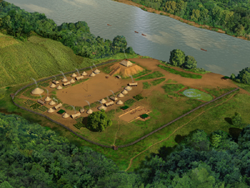
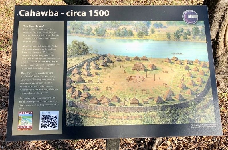
- Ancient ditches at Cahaba (Dallas County, AL)
- In Dallas County, ancient ditches are noted at Cahaba (or Cahawba), the site of Alabama’s first state capital at the confluence of the Alabama and Cahaba rivers. These earthworks lie near present-day Old Cahawba Archaeological Park, southwest of Selma.pioneer.pdf
-
- Group of three mounds on the Alabama River (Macon County, AL)
- A group of three mounds is located about 10 miles below Little Tallassee on the Alabama River, in Macon County, Alabama. “Little Tallassee” refers to a historic Creek town site on the river; the mounds lie downstream along the Alabama in east-central Alabama.pioneer.pdf
Birmingham District & Central Ridge Country
- Varna mound near Repito gold mine (Chilton County, AL)
- A mound is recorded at Varna, on the Louisville and Nashville Railroad near the old Repito gold mine, section 16, township 21 south, range 16 east, in Chilton County, central Alabama. This is roughly between Clanton and the Coosa River corridor.pioneer.pdf
-
- Stone heaps near Jemison (Chilton County, AL)
- Stone heaps were noted in township 28 north, range 14 east (Stephens meridian), about three and a half miles northeast of Jemison Station on the L&N Railroad, also in Chilton County. These are interpreted as stone burial or memorial features.pioneer.pdf
-
- Stone heap near Siluria (Shelby County, AL)
- About one mile east of Siluria on the South and North Alabama Railroad (a division of the Louisville and Nashville), a stone heap was described in Shelby County, central Alabama. Siluria sat just south of present-day Alabaster.pioneer.pdf
-
- Village Creek mounds and “furnaces” near Birmingham (Jefferson County, AL)
- In Jefferson County, a group of mounds in township 17 south, range 1 east lies about four miles north of Birmingham and west of the Louisville and Nashville Railroad. Additional mounds and so-called “furnaces” occur along Village Creek near Birmingham, all within the Birmingham District.pioneer.pdf
-
- Mounds near Jonesboro (Jefferson County, AL)
- A small group of mounds is recorded near old Jonesboro, on section 8, township 19 south, range 4 west (Huntsville meridian), in western Jefferson County, Alabama. This area lies southwest of present-day Bessemer.pioneer.pdf
-
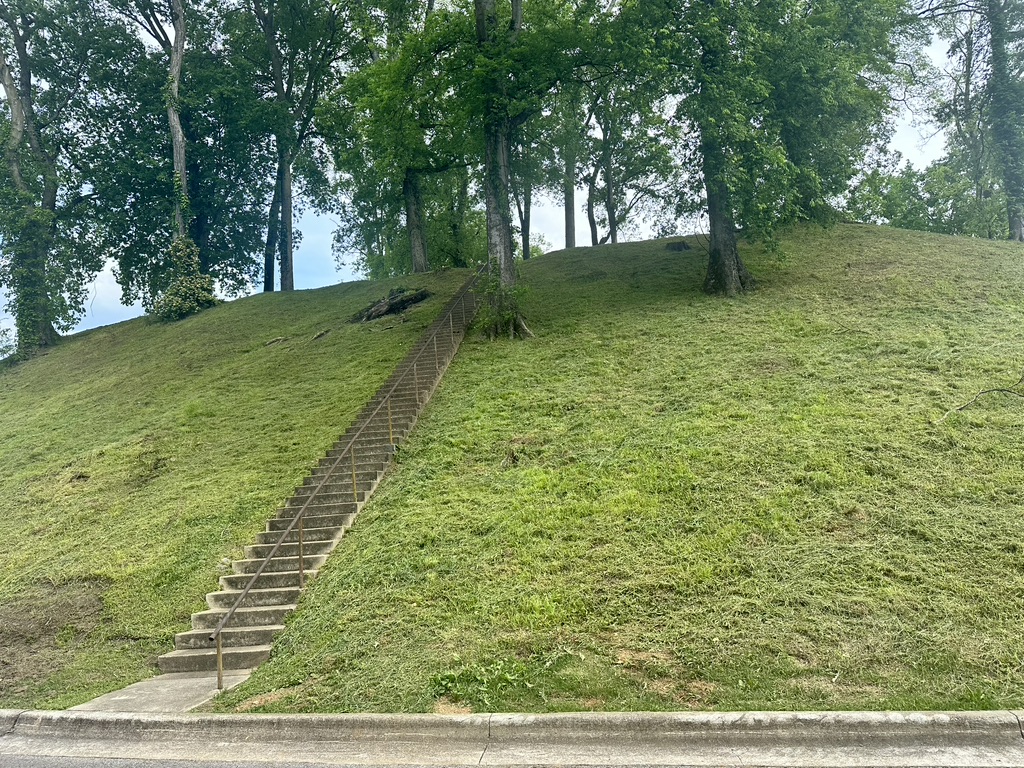
- Large quadrangular mound near Elyton (Jefferson County, AL)
- A large, quadrangular flat-topped mound, “the most beautiful mound” Duffee had seen, stood a short distance from Elyton (the early name for Birmingham), on the left side of the old Huntsville (Tennessee) road just after crossing a creek. It stood amid level lands with ample water, resembling Aztec-style mounds and likely served ceremonial or council purposes.pioneer.pdf
Blount, Marshall & Neighboring Mountain Valleys (North-Central Alabama)
- Hampton Cave burial site near Huntersville (Marshall County, AL)
- About one mile west of “Huntersville” (likely old Huntsville or a local community of that name within modern Marshall County), Duffee describes a burial cave known as “Hampton Cave,” with partial exploration revealing human remains and artifacts. Marshall County lies along the Tennessee River’s Guntersville basin in north Alabama.pioneer.pdf
-
- Blountsville caches and caves (Blount County, AL)
- A cache of 17 chipped implements, spearheads, and similar tools was found in a field near Blountsville.pioneer.pdf
-
- A burial cave known as “Camp’s Cave,” about 15 miles south of Blountsville, contained skeletons, wooden troughs, bark matting, copper items, and shell ornaments.pioneer.pdf
-
- These sites are in Blount County, north-central Alabama, between Birmingham and the Tennessee River.pioneer.pdf
-
- Mound groups in Murphree’s and Brown’s valleys, and along Locust & Warrior forks (Blount County, AL)
- Duffee records multiple low mounds, four to seven feet high, in Murphree’s Valley, Brown’s Valley, and along the Locust Fork and Little Warrior River in Blount County. Several distinct groups occur in the bottomlands of the Locust Fork of the Black Warrior River, near the junction of the Little Warrior and Locust Fork and west of the Mulberry Fork. These are in the hill country north of Birmingham, centered on Blount County.pioneer.pdf
Out-of-State Example: Clark County, Arkansas
Although the article focuses on Alabama, Duffee includes a notable comparative site in Arkansas.pioneer.pdf
- Large mound and shell beds near Amity (Clark County, AR)
- In Clark County, Arkansas, near a salt spring on a small creek flowing into the Ouachita (Washita) River, a large mound yielded iron hatchet-shaped implements. Additional shell beds lie four miles north of the town of Amity, in section 17, township 5 south, range 23 west, on the second bottom of the Caddo River above overflow. This is in southwest Arkansas, near the modern Amity–Caddo River area.weekendwanderluster.blogspot
- pioneer.pdf
How to Use These Locations Today
- Many of these sites can be approximated using:
- County name + nearest town (e.g., “mounds near Bridgeport, Jackson County, Alabama”).pioneer.pdf
-
- River names and junctions (Coosa, Tallapoosa, Alabama, Tennessee, Little River, Locust Fork, Black Warrior).pioneer.pdf
-
- Historic forts and parks (Fort Toulouse–Fort Jackson, Old Cahawba, Choccolocco Creek Archaeological Complex).hmdb+1
- pioneer.pdf
-
- For on-the-ground exploration or deeper research:
- Cross-reference these descriptions with modern USGS topo maps and county GIS layers.
- Consult Alabama Historical Commission, the Alabama Mound Trail, and local archaeological surveys for access rules and updated site conditions.alabamamoundtrail+1
This re-mapping of Duffee’s “Pioneer Days” shows just how dense the mound landscape of Alabama really is—and how much of it still lies in plain sight along today’s roads, creeks, and river corridors.pioneer.pdf
- https://www.loc.gov/resource/sn85038485/1909-10-11/ed-1/?sp=7&q=Arkansas+Mound+prehistoric&r=-0.192,-0.034,0.778,0.465,0
- https://ppl-ai-file-upload.s3.amazonaws.com/web/direct-files/attachments/28700284/aed7f352-a3c9-4409-a1a1-71bf2dc8189a/pioneer.pdf
- https://alabamamoundtrail.org/mound-site/choccolocco/
- https://www.hmdb.org/m.asp?m=144926
- https://en.wikipedia.org/wiki/Choccolocco_Creek
- https://www.forestry.alabama.gov/Pages/Management/ChoccoloccoSF.aspx
- https://msnha.una.edu/george-washington-goethals-and-the-muscle-shoals-canal/
- https://www.hmdb.org/m.asp?m=125572
- https://topoquest.com/place-detail.php?id=137284
- http://weekendwanderluster.blogspot.com/2020/09/choccolocco-creek-archaeological.html
- https://www.megalithic.co.uk/article.php?sid=23386
- https://www.topozone.com/alabama/autauga-al/summit/parker-mountain-2/
Gallery

Discussion (0)
Please sign in to join the discussion
No comments yet. Be the first to share your thoughts!