Echoes of Little Egypt: Visiting the Lost Earthworks and Wild Landscapes of Southern Illinois
Cahokia: City of the Sun
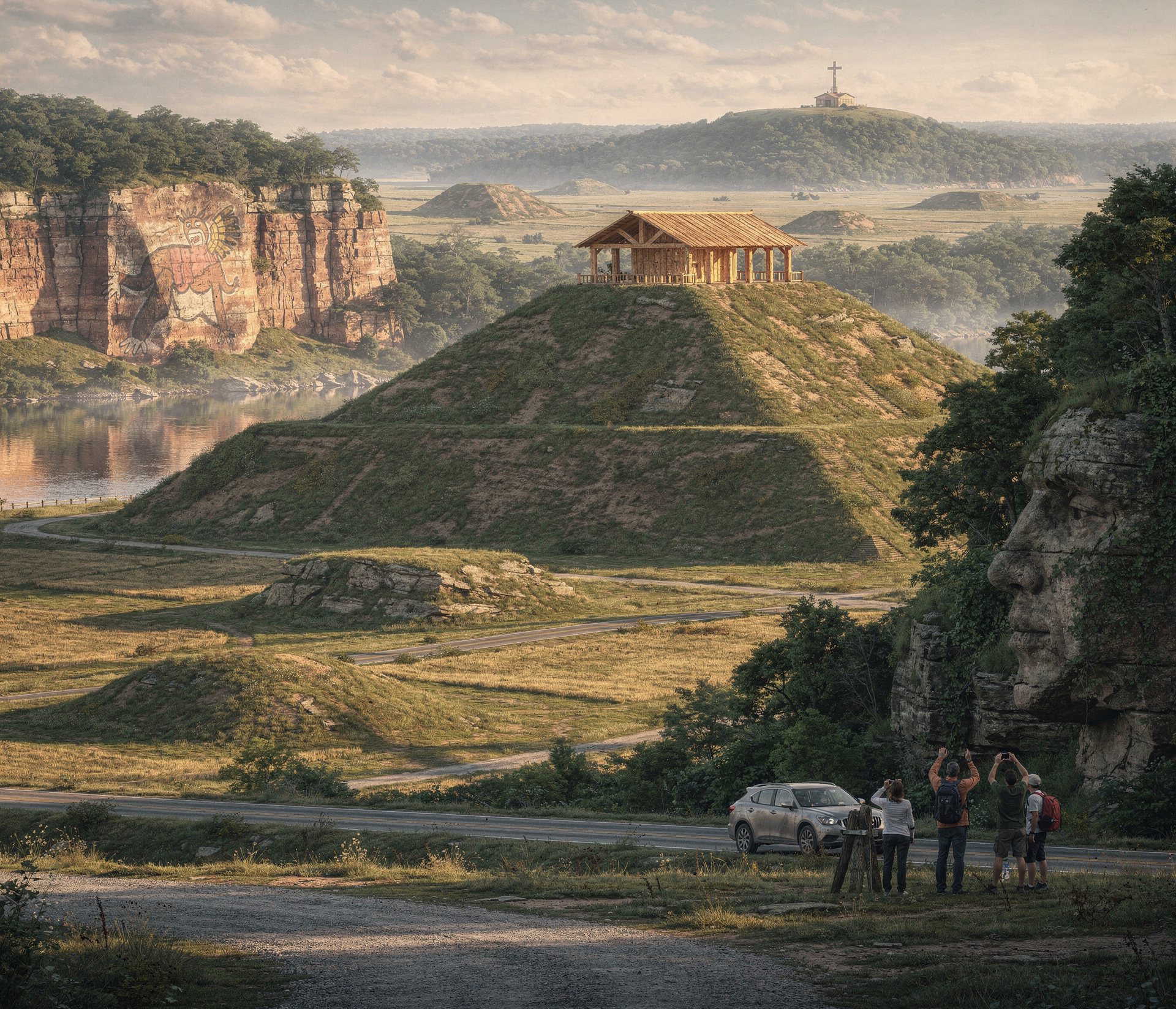
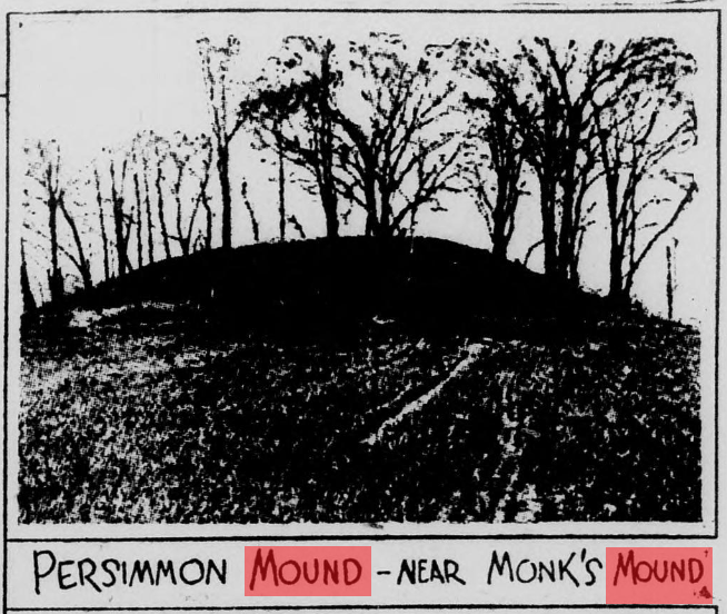
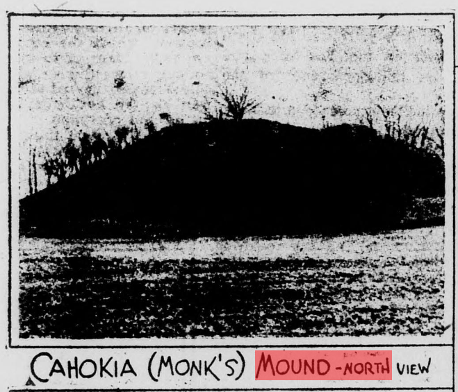
The old article opens with the “Egyptian Empire” of southern Illinois and its greatest mystery: the vast earthworks we now call Cahokia Mounds. Less than five miles from East St. Louis, a grid of paved roads now leads straight to what early writers described as “gigantic ciphers of a past age,” once at least one hundred mounds strong and now reduced to about seventy.
In 1789, General George Rogers Clark recorded Native traditions that the mounds were the work of their forefathers and were once “as numerous as trees in the woods,” hinting at a dense pre‑Columbian metropolis that may have held 100,000 people or more. Archaeologists in the 1920s, led by Warren K. Moorehead and later the University of Illinois, confirmed that this was the largest archaeological site in the United States, centered on the immense Monks Mound and ringed by plazas, stockades, and a wooden solar calendar now called “Woodhenge.”
Where to visit now
- Cahokia Mounds State Historic Site & Monks Mound – Collinsville, Illinois, just east of St. Louis; visitors can climb Monks Mound, walk among preserved mounds, and tour the Interpretive Center.
-
- Woodhenge and reconstructed stockade – Within Cahokia Mounds State Historic Site, marked by interpretive trails and signage.
Lakes, caves, and stone faces
Moving out from Cahokia, the article describes a series of watery and rocky sanctuaries—artificial lakes, cave‑riddled hills, and legendary stone visages carved by time. Near Effingham, Lake Kanaga is portrayed as an artificial but seemingly natural 12‑acre lake in an ancient stream bed, attracting wildfowl and surrounded by meadows, hawthorn, and wild crab trees, though it is not a major modern attraction under that old name.
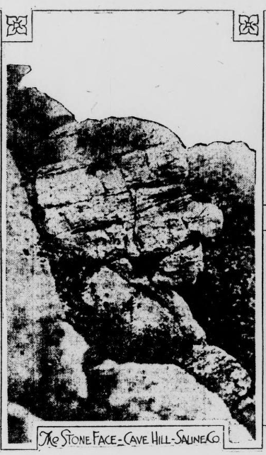
Farther south, southeast of Harrisburg, rises Cave Hill, a 700‑foot high knob overlooking the Saline River bottoms, riddled with caverns, rock carvings, and a prominent feature called Stone Face that early writers linked to prehistoric legends. The same landscape rolls into Gold Hill, Wild Cat Hill, the Shawneetown Lakes, and an old rock‑walled “stone fort” near the village of Stonefort, reminders of a long‑vanished people.
Where to visit now
- Saline County State Fish & Wildlife Area (Cave Hill & trails) – Near Equality/Harrisburg, with designated hiking routes including a “Cave Hill” trail across bluffs and forest.
-
- Stonefort area – The village of Stonefort in Saline County remains the gateway to old “stone fort” ruins and hill country; check local hiking guides or Shawnee National Forest resources for trailheads.
- Shawneetown / Old Shawneetown & nearby hills – The historic river town and surrounding hills, including Gold Hill and Wild Cat Hill, lie along the Ohio River corridor in Gallatin County.
Wolf Lake, Bald Knob, and the southern highlands
The narrative then swings west to Union County, one of Illinois’ most picturesque corners, where the Mississippi River skirts a wall of bluff‑top forests and hidden lakes. Wolf Lake is described as a classic oxbow lake—once a channel of the Mississippi—lying below pine‑covered hills that hold the state’s only stand of southern yellow pine and even wild azalea, more typical of the distant Alleghenies.
North of the river corridor, the village of Alto Pass sits at the highest railroad point in Illinois, backed by Bald Knob, one of the highest peaks in the state. From the treeless summit of Bald Knob, visitors can look out over the Mississippi lowlands and the rolling Ozark uplands, while its forested slopes hold some of the finest timber in southern Illinois. Nearby high ridges such as Atwood Ridge and Willow Springs round out a landscape the article urges to preserve as state forest or parks.
Where to visit now
- Wolf Lake & LaRue‑Pine Hills – Near the community of Wolf Lake in Union County; reach via Illinois Route 3 and local roads into the LaRue‑Pine Hills/Otter Pond area of the Shawnee National Forest.
-
- Alto Pass and Bald Knob Cross – Alto Pass, Illinois; visitors can drive up to the Bald Knob Cross of Peace and surrounding overlooks for panoramic views.
-
- Atwood Ridge & Willow Springs vicinity – Scenic ridges near the Mississippi in Union County; generally accessed via rural roads and Shawnee National Forest trail systems.
Fern Cliff, natural bridges, and canyon country
The story next plunges into the canyon lands of Johnson and Pope counties, where sandstone cliffs and hidden hollows rival anything in the state. Near Goreville lies Fern Cliff, a maze of massive sandstone walls, detached blocks, rock amphitheaters, waterfalls, and caves, draped in ferns and timber—a long‑time favorite of locals before it was more formally recognized. East of Fern Cliff, the original writer praises the train ride from Parker to Vienna as perhaps the most scenic in Illinois and notes cypress swamps along the Cache River that evoke Louisiana and Arkansas.
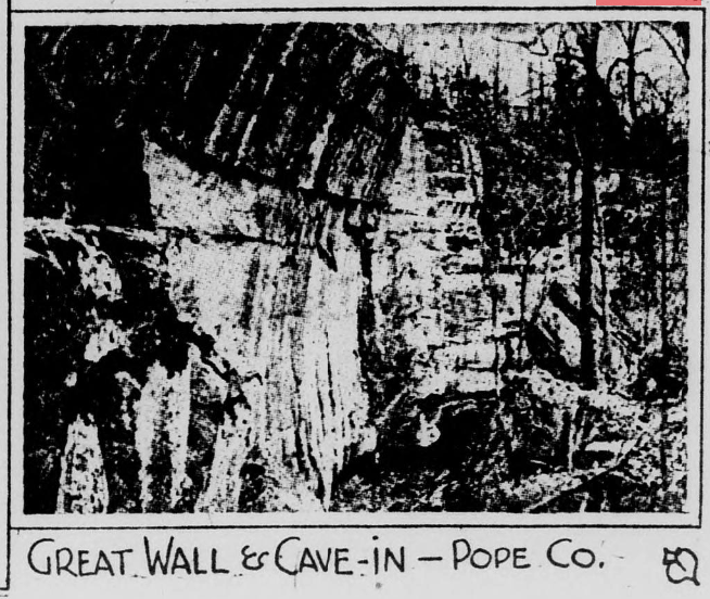
In Pope County, the terrain becomes wilder still, with deep “hollows,” a great Natural Bridge, and the impressive Sand Cave, all surrounded by rare ferns including the delicate filmy fern, almost unknown elsewhere in the Midwest. Lusk Creek’s banks are lined with waterfalls and gorges, while Dixon Springs—already a resort in the article’s day—boasts mineral springs, shady canyons, and old‑growth trees.
Where to visit now
- Ferne Clyffe State Park – Near Goreville, Johnson County, encompassing the historic “Fern Cliff” area with waterfalls, bluffs, and hiking trails.
-
- Cache River State Natural Area – South of Vienna, protecting the remaining cypress‑tupelo swamps and bottomland forests along the Cache River.
-
- Shawnee National Forest (Jackson Hollow, Natural Bridge, Sand Cave, Lusk Creek) – Pope County; trailheads for Jackson Falls, Sand Cave, Lusk Creek, and natural bridge formations are managed as part of the national forest.
- Dixon Springs State Park – Central Pope County, preserving springs, canyons, and forested slopes described in the original article.
Blufflines, pictographs, forts, and vanished capitals
The closing stretch of the old piece is a rapid‑fire tour of bluffs and historic river towns that tie natural drama to frontier history. Along the Mississippi between Gorham and Grand Tower in Jackson County rise the cliffs of Fountain Bluff, an isolated sandstone “rock island” standing 300–400 feet above the floodplain, cut with ravines, grottos, springs, and Native American rock art. At its feet, the river narrows into rapids, and just downstream stands the limestone formation known as the Devil’s Bake Oven near the river town of Grand Tower.
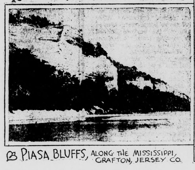
Farther east and south, Hardin County’s Hicks Dome and cave‑riddled hills, Elizabethtown and Cave‑In‑Rock on the Ohio River, and the swamps of the lower Cache near Thebes all appear as wild, half‑accessible corners of Illinois. The article also nods to Fort Massac at Metropolis, a key frontier stronghold, and to old Kaskaskia—the first capital of Illinois—largely eaten away by the Mississippi, with only the area near Fort Gage retaining its historic significance. Finally, north of Alton, the Piasa Bluffs tower over the Mississippi, their cliffs long associated with the legendary Piasa Bird whose painted image still looms over the river today.
Where to visit now
- Fountain Bluff – West of Murphysboro between Gorham and Grand Tower; access via Happy Hollow Road off Illinois Route 3 for hiking and views.
-
- Devil’s Bake Oven & Grand Tower – Near Grand Tower, Jackson County; visible from the riverfront and local overlooks along the Mississippi.
-
- Cave‑In‑Rock State Park – On the Ohio River in Hardin County, preserving the famous river cave and outlaw legends mentioned in the article.
- Thebes & lower Cache River swamps – Thebes in Alexander County offers views of the river bluffs; nearby Cache River bottoms hold remnant cypress‑tupelo swamps.
- Fort Massac State Park – Metropolis, Illinois, preserving the reconstructed fort and its pioneer history on the Ohio River.
- Kaskaskia / Fort Gage area – Historic Kaskaskia Island and Fort Kaskaskia State Historic Site in Randolph County mark the vicinity of the old capital and fortifications.
- Piasa Bird and Piasa Bluffs – Just north of Alton along the Great River Road; a modern mural of the Piasa Bird adorns the bluff face above the Mississippi.
These are the living counterparts of the “strange and fantastic features” your source article showcased—a continuous road‑trip route where visitors can still walk the mound‑tops, climb the bluffs, and step into the same hollows and caves that stirred curiosity a century ago.
https://www.loc.gov/resource/sn92053739/1925-03-08/ed-1/?sp=11&q=Arkansas+Mound+prehistoric&r=0.618,0.277,0.327,0.212,0
Gallery
Discussion (0)
Please sign in to join the discussion
No comments yet. Be the first to share your thoughts!